Forecasting the success of fishing trips, for millions of Fishbrain users
Forecasting the success of fishing trips, for millions of Fishbrain users
We joined forces with the engineers at Fishbrain to develop and deploy a machine learning-based service that predicts what type of fish an angler is likely to catch on any given day, anywhere in the world.
Background
With more than 11 million users, Fishbrain is the world’s largest fishing app that connects anglers with technology to change the way people fish. Users can log catches, share photos, make comments and also find the right gear for maximizing the chance of success on the next fishing trip. The client wanted to find a way to help their users get a better fishing experience.
Solution
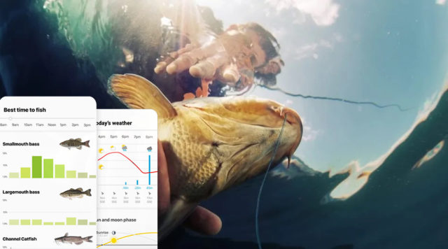
Data from 2.5 million catches were collected and refined. Each data point was annotated with date, time, location, and fish species. Detailed weather information was added to each catch; air temperature, air pressure, wind speed, cloud cover, and precipitation. Temporal data was transformed into astronomical conditions such as moon phase, solar irradiation, and azimuth angle. A global climate model was created, providing information on historical weather patterns, vegetation, and geology. Given its input, the final model predicts the likelihood of catching each of a large set of tracked fish species over the course of a day and powers BiteTime™, Fishbrain’s fishing forecast utility. The project received attention from Amazon and was published as a featured success story on Amazon AWS.
Tools/Tech
Catch data was collected and combined with various internal and external sources. Data pipelines were developed for processing data from internal and external APIs. Various cloud-managed services (such as Amazon Sagemaker and Lambda functions) were utilized for efficient model training, tuning, and serverless deployment. Development as well as deployment was mainly performed and orchestrated in Python and open source libraries.
You can read more about the case, shared by AWS here: https://aws.amazon.com/partners/success/fishbrain/
—
Million users
Fishbrain has over 11 million users.
—
Million catches
They have over 10 million registered catches.
—
Million catches used for training
We trained the forecasting model on 2.5 million historical catches.

Having an AWS machine learning partner allowed us to move instantly instead of spending months upscaling and building tooling.
Rickard Svedenmark, CTO, Fishbrain